Introduction
India is rewriting its infrastructure story — not just with highways, but with high-impact vision. The Ganga Expressway Route Map and Completion Date 2025 are now the focus of national attention. With the Indian Air Force conducting night landings on this expressway and massive development plans underway, the Ganga Expressway is set to become one of India’s most important roadways — in more ways than one.
What is the Ganga Expressway?
The Ganga Expressway Route Map and Completion Date 2025 are crucial parts of a 594 km long, 6-lane (expandable to 8) greenfield expressway that stretches from Meerut in Western UP to Prayagraj in Eastern UP. This expressway is designed to reduce travel time, boost trade, and enhance military logistics — all while passing through the heart of Uttar Pradesh. Developed by the Uttar Pradesh Expressways Industrial Development Authority (UPEIDA), the project is a cornerstone of the state’s infrastructure vision.
Ganga Expressway Route Map

The Ganga Expressway Route Map and Completion Date 2025 highlight the strategic design of this corridor:
- Start Point: Bijauli village near Meerut
- End Point: Judapur Dandu village in Prayagraj
The expressway passes through 12 major districts:
- Meerut
- Hapur
- Bulandshahr
- Amroha
- Sambhal
- Budaun
- Shahjahanpur
- Hardoi
- Unnao
- Rae Bareli
- Pratapgarh
- Prayagraj
The Ganga Expressway Route Map and Completion Date 2025 provide a vital link connecting western and eastern Uttar Pradesh.
Ganga Expressway Village List (Key Villages)
Some prominent villages along the route include:
- Meerut District: Bijauli, Siwaya
- Sambhal: Asmoli, Pawansa
- Shahjahanpur: Katra, Madnapur
- Prayagraj: Judapur Dandu, Handia
In total, over 500 villages will benefit directly or indirectly from the expressway. The Ganga Expressway Route Map and Completion Date 2025 reveal how it can transform local access, economies, and services.
Which Company Made Ganga Expressway?
Understanding the builders is essential when talking about the Ganga Expressway Route Map and Completion Date 2025.
The construction is divided among two major players:
- IRB Infrastructure Developers Ltd: Awarded Packages 1 to 3
- Adani Enterprises Ltd: Handling Packages 4 to 12
These companies are implementing advanced construction technologies to meet strict quality and timeline standards. The Ganga Expressway Route Map and Completion Date 2025 show how critical and massive this execution process is.
Shahjahanpur Airstrip: India’s First Night-Landing Expressway
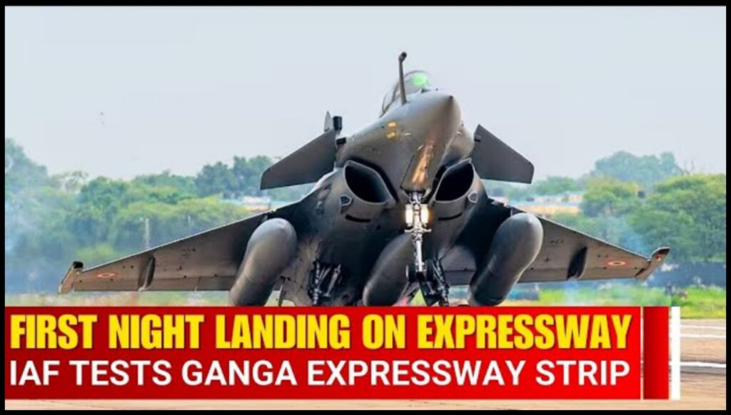
One of the standout features of the Ganga Expressway is the 3.5 km long airstrip near Shahjahanpur. In April 2025, the Indian Air Force conducted successful day and night fighter jet landings and takeoffs here — a first for any expressway in the country. The Ganga Expressway Route Map and Completion Date 2025 also emphasize this unique dual-use infrastructure.
Highlights:
- 3.5 km emergency airstrip suitable for fighter jets
- Night landing capabilities (first in India)
- 250+ CCTV cameras for high-security monitoring
- Enables emergency defense or disaster-response operations
This integration of civil and military infrastructure, as showcased in the Ganga Expressway Route Map and Completion Date 2025, reflects modern strategic planning.
Ganga Expressway Completion Date
The Ganga Expressway Route Map and Completion Date 2025 reveal that while the project was originally expected to be completed by December 2024, delays occurred due to environmental restrictions like GRAP-4 in the NCR region. As of April 2025, construction is around 79% complete. The revised target launch is set for July 2025, just before the Mahakumbh in Prayagraj.
Economic and Social Impact
The Ganga Expressway Route Map and Completion Date 2025 aren’t just about travel — they represent a massive leap in regional development:
- Industrial Clusters: Planned along the corridor to promote MSMEs and employment
- Rural Development: Increased access to markets, education, and healthcare
- Tourism Growth: Faster travel to religious hubs like Haridwar, Prayagraj, and Varanasi
- Bundelkhand Link: Planned connection via Farrukhabad to extend benefits to underdeveloped areas
The Ganga Expressway Route Map and Completion Date 2025 make it clear: this project connects more than cities — it connects futures.
Why It Matters
Whether you’re a daily commuter or a policymaker, the Ganga Expressway Route Map and Completion Date 2025 carry significance:
- Travelers will save time and enjoy smoother rides
- Villagers gain new economic and educational opportunities
- Businesses cut down logistics time and cost
- Defense forces get a high-speed deployment route
The Ganga Expressway Route Map and Completion Date 2025 showcase a unique intersection of strategy, civilian need, and development.
Conclusion
The Ganga Expressway Route Map and Completion Date 2025 tell the story of a road that’s far more than transportation. It’s about building a connected, secure, and progressive Uttar Pradesh. From hosting night fighter jet landings to uplifting over 500 villages, and preparing for Mahakumbh 2025 — the expressway is a blueprint for future-ready infrastructure.
As India accelerates into the next decade, projects like the Ganga Expressway Route Map and Completion Date 2025 highlight how roads can pave the way for both progress and preparedness.
FAQs
What is the Ganga Expressway and why is it important?
The Ganga Expressway is a 594 km long, access-controlled expressway in Uttar Pradesh. It will connect Meerut to Prayagraj, making travel between these cities faster and more efficient. This project is crucial for improving connectivity, reducing traffic congestion, and promoting regional development. It will cut down travel time significantly, from 10-12 hours to just 6-8 hours.
What are the major features of the Ganga Expressway?
Some key features of the Ganga Expressway include: Length: 594 km (expandable to over 1,000 km in the future) Speed Limit: 120 km/h Lane Configuration: 6 lanes (expandable to 8 lanes) Bridges and Flyovers: Including a 960-meter bridge over the Ganga River and multiple flyovers and underpasses Emergency Airstrip: A 3.5 km stretch will serve as an emergency landing strip for military use Toll Plazas: 2 main plazas and 12 ramp plazas along the route
How will the Ganga Expressway affect local communities?
The Ganga Expressway will enhance regional development by connecting smaller towns and cities to major commercial hubs. It is expected to: Boost tourism by making religious and cultural sites more accessible Facilitate faster transportation of goods, benefiting local businesses Provide better infrastructure, attracting investments and creating new job opportunities
What are the environmental considerations for the Ganga Expressway?
The Ganga Expressway project has been designed with eco-friendly measures to reduce its environmental impact. Efforts have been made to avoid deforestation and minimize disruption to local wildlife. Additionally, several underpasses and overpasses will be built to ensure smooth passage for animals and reduce habitat fragmentation.
Did the Indian Air Force conduct drills on the Ganga Expressway?
Yes! On May 2, 2025, the Indian Air Force conducted “land and go” drills on the expressway in Shahjahanpur. Fighter jets like Rafale, SU-30, and MiG-29 performed exercises to demonstrate the expressway's ability to be used as an emergency runway, highlighting its strategic importance
What districts will the Ganga Expressway pass through?
The Ganga Expressway will pass through 12 districts, including: Meerut Hapur Bulandshahr Amroha Sambhal Budaun Shahjahanpur Hardoi Unnao Rae Bareli Pratapgarh Prayagraj
How will the Ganga Expressway impact travel between Meerut and Prayagraj?
Once completed, the Ganga Expressway will drastically reduce travel time between Meerut and Prayagraj, cutting down the journey from 10-12 hours to just 6-8 hours. This will not only make travel more convenient but also encourage economic and cultural exchange between the cities.
How much will it cost to use the Ganga Expressway?
The Ganga Expressway will have toll plazas, with fees based on the distance traveled. However, the cost is expected to be reasonable, considering the time saved and the improved quality of roads. It will be a more affordable and time-efficient option for travelers.